How to Read Chilliwack's Flood Monitoring and Stay Prepared During High Water Season

Chilliwack sits on the largest alluvial fan in Canada — a geological fact that explains why nearly 10,000 of our properties lie within designated floodplains. Every spring, as the snowpack melts across the Cascade and Coast Mountains, the Fraser and Vedder Rivers remind us that living in this valley comes with responsibilities. Understanding how to read flood monitoring data and what it means for your specific Chilliwack neighbourhood isn't just prudent — it's part of being a prepared member of our river-dependent community.
Where Does Chilliwack's Flood Data Come From?
The City of Chilliwack doesn't operate in isolation when tracking water levels. Real-time data flows from multiple sources that locals should bookmark before the freshet season begins. The Government of Canada's Water Office maintains gauges at key points along the Fraser River, including the Hope gauge that predicts what reaches us downstream. Closer to home, the Vedder River gauge at the Vedder Crossing bridge gives Chilliwack residents direct insight into what's happening in our backyard.
The City also operates its own monitoring network through the Chilliwack Emergency Operations Centre, which combines federal data with local observations. During high water events, staff from Chilliwack's Public Works Department physically inspect dikes and pump stations along the Vedder, Luckakuck, and Fraser foreshore — adding human assessment to the raw numbers.
Here's what separates informed Chilliwack residents from those caught off-guard: knowing that river levels alone don't tell the complete story. The timing of snowmelt in the mountains, recent precipitation throughout the Fraser Valley, and even tides at the river's mouth all factor into whether Chilliwack's dikes will be tested. The City publishes weekly freshet bulletins during spring months that contextualize the raw data — these deserve your attention far more than daily level fluctuations.
How Do I Know If My Chilliwack Property Is at Risk?
Not all of Chilliwack faces the same flood risk — and this isn't only about proximity to the river. The City maintains detailed floodplain maps that categorize properties by hazard level, accounting for factors like elevation, dike protection status, and historical flood patterns. Areas like Sardis near the Vedder River, portions of Yarrow along Sumas Prairie, and low-lying sections of Fairfield Island have different risk profiles than neighbourhoods perched higher toward Chilliwack Mountain or Promontory.
To check your specific status, visit the Chilliwack floodplain mapping portal through the City's planning department. Enter your address and you'll see whether your property sits within the 200-year floodplain — the standard used for building restrictions and insurance purposes. But don't stop there. The mapping shows approximate inundation depths during major events, which matters for preparation. A property that sees 0.3 metres of predicted flooding requires different preparation than one facing 2 metres.
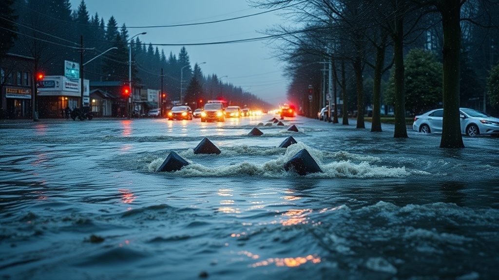
Chilliwack's dikes provide significant protection — they're maintained to provincial standards and inspected regularly. However, dike-protected areas can still face flooding from overwhelmed storm drains, backup from the numerous creeks running off Chilliwack Mountain, or in extreme cases, dike overtopping. The 1948 flood that devastated our community remains within living memory for some Chilliwack families, and it shaped the extensive dike system we rely on today.
Insurance considerations matter too. Standard homeowner policies exclude overland flooding, though many Chilliwack residents qualify for the federal Disaster Financial Assistance program for uninsurable losses during declared emergencies. Understanding your coverage gaps before the waters rise lets you make rational decisions rather than panicked ones.
What Should Chilliwack Residents Do When Flood Watches Are Issued?
When the City of Chilliwack issues a flood watch or warning, the window for preparation narrows quickly. Having a household plan specific to our local geography makes the difference between orderly response and last-minute scrambling. Start with the essentials: secure copies of important documents in waterproof containers, photograph your property and belongings for insurance purposes, and know your evacuation route to higher ground.
Chilliwack's designated reception centres during evacuations typically include Chilliwack Secondary School and Sardis Secondary School — locations with the capacity to shelter displaced residents and the infrastructure to coordinate with Emergency Support Services. Know which centre serves your neighbourhood before you need to. If you have livestock or large animals (common in our rural eastern neighbourhoods), the Chilliwack Agricultural Society coordinates animal evacuations separately from human ones — their contact information should be in your emergency file.
Physical preparation includes clearing drains and culverts on your property, moving valuables to upper floors if you're in a flood-prone zone, and having sandbag materials ready. The City provides sand and bags at designated locations during active flood threats — typically at fire halls in affected areas. Don't wait until the announcement; the lines form quickly, and supplies can deplete.
Vehicle positioning matters more than people realize. Park on higher ground if possible, and keep fuel tanks at least half full during freshet season. Chilliwack's road network includes several low-lying sections that close during flood events — including parts of Keith Wilson Road, Lickman Road, and sections of the dike access roads used by farmers throughout our agricultural community. Having alternate routes mapped prevents getting stranded.
How Can I Stay Connected to Official Updates?
During flood season, reliable information becomes your most valuable resource. The City of Chilliwack uses multiple channels to reach residents, and subscribing to all of them creates redundancy if one system fails. The Chilliwack Emergency Alert system sends notifications to registered phones — enrollment is free through the City's website. Follow the City of Chilliwack's official social media accounts, where updates post immediately during developing situations.
Local media plays a role too. The Chilliwack Progress and local radio stations broadcast official updates during emergencies. But be selective about your sources — social media rumours spread faster than water during crisis moments, and misinformation can send people scrambling unnecessarily or lull them into complacency when action is needed.
Neighbourhood-level communication matters in Chilliwack's tight-knit communities. Many areas — particularly in rural eastern Chilliwack and along the Fraser — have established phone trees or social media groups where residents share observations about changing conditions. These informal networks complement official sources, providing ground-level intelligence about road conditions, sandbag availability, or localized flooding that might not yet appear in official communications.
The agricultural community in Chilliwack has particularly sophisticated networks, born from generations of dealing with seasonal water management. If you're new to farming here, connecting with the Chilliwack Chamber of Commerce agriculture committee or local farm associations provides access to experienced voices who've handled multiple freshet seasons.
Building Long-Term Resilience in Our Community
Individual preparedness scales to community resilience. Chilliwack's dike system — maintained through partnerships between the City, provincial authorities, and local improvement districts — requires ongoing investment and public support. The City's flood mitigation strategy extends beyond dikes to include retention ponds, upgraded stormwater systems in newer developments, and land use planning that discourages construction in the highest-risk zones.
Residents can participate in this broader effort by attending public meetings on infrastructure projects, supporting the maintenance fees that keep our protection systems functional, and advocating for continued investment in flood mitigation. The Chilliwack River Valley and Sardis-Vedder areas have seen significant upgrades in recent years, but infrastructure ages and standards evolve — our vigilance shouldn't wane just because we haven't seen a major flood recently.
Living with rivers means accepting their rhythms while respecting their power. Chilliwack's relationship with the Fraser and Vedder has always been one of careful coexistence — from the Stó:lō communities who originally settled these banks to the modern city we've built. Understanding flood monitoring isn't about living in fear; it's about being informed neighbours who look out for one another when the waters rise.